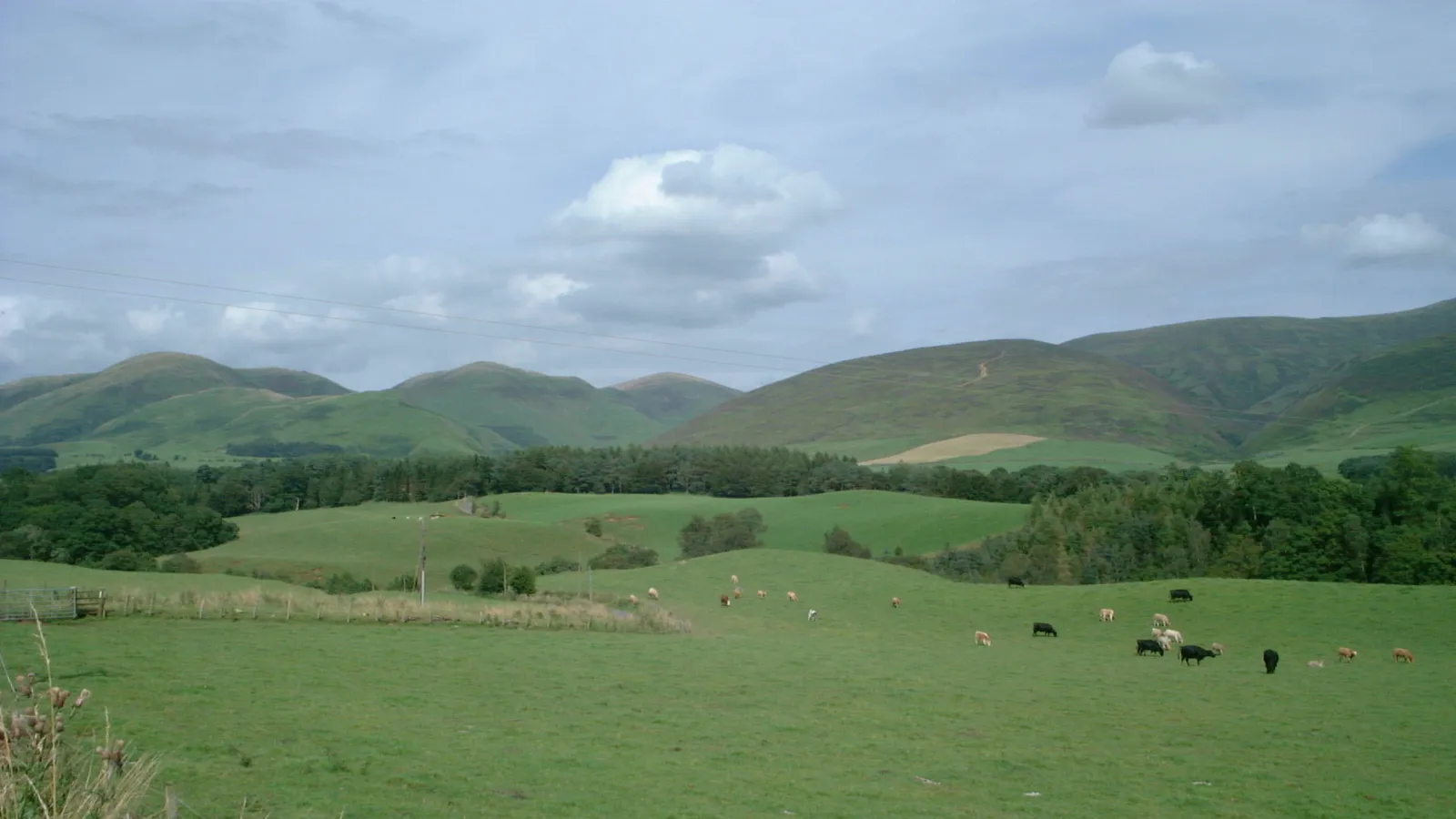

Galloway Forest & the Southern Uplands
Contents
Legend/Myth Opener
Galloway is routinely overlooked in popular accounts of "wild Scotland," which tend to fix attention on the Highlands and islands further north. The Southern Uplands around Galloway Forest Park are, in fact, home to the highest peak south of the Highland line, one of Europe's largest forest parks, and the first Dark Sky Park designated anywhere in the United Kingdom — a set of superlatives rarely associated with a region so often treated as a drive-through en route to somewhere else.
TL;DR
- established Galloway Forest Park was designated the UK's first Dark Sky Park, achieving Gold Tier status from the International Dark-Sky Association in November 2009 — stated precisely because "dark sky" tourism claims are common across Scotland, and Galloway's specific first-in-the-UK status and tier level deserve accurate, dated attribution.
- established The Merrick, at 843 m, is the highest mountain in the Southern Uplands and in southern Scotland as a whole — stated directly because southern Scotland's hills are frequently assumed to be uniformly modest, when this specific summit is a genuine significant peak by British standards.
- established Galloway Forest Park covers 774 km², making it one of the largest forest parks in Europe, almost entirely the product of 20th-century state afforestation beginning in 1947 rather than ancient native woodland — this is stated directly because the park's "forest" character is substantially planted and managed, not a surviving ancient wildwood.
- established The 144-mile sightline sometimes claimed between the Merrick and Snowdon in Wales is the longest confirmed line of sight in the British Isles, though Lamachan Hill typically blocks the actual view in practice — stated with this caveat because the claim is true in theoretical geometric terms but misleading if presented as something a visitor can reliably see.
- traditional The region's association with the 17th-century Covenanters and the "Killing Time" persecution is well documented through surviving memorials such as the Martyrs' Tomb near Glen Trool, though some individual local martyr narratives rely on later commemorative tradition rather than full contemporaneous documentation, and this distinction is worth maintaining.
Key Facts
- Location/Region
- Dumfries and Galloway, south-west Scotland, within the historic counties of Kirkcudbrightshire and Wigtownshire
- Height/Area/Scale
- Galloway Forest Park: 774 km² (299 sq mi); the Merrick: 843 m, highest point in the Southern Uplands and southern Scotland
- Geology/Formation
- Southern Uplands granite intrusions and older sedimentary rock, shaped by the same Caledonian mountain-building episode that formed much of the wider Scottish Highlands, later heavily glaciated; scattered granite erratics and glacially carved valleys and lochs throughout
- Protected status
- Gold Tier Dark Sky Park (International Dark-Sky Association, since November 2009, the first in the UK); Galloway and Southern Ayrshire UNESCO Biosphere designation covers the wider region; multiple SSSI sites within the park
- Managed/Owned by
- Forestry and Land Scotland (established as a forest park in 1947)
- Access notes
- Extensive waymarked walking and mountain biking trails, including the 7stanes mountain bike network; the Merrick ascent from Glen Trool is a long but non-technical hillwalk (c. 14.5 km round trip); dark-sky viewing is best away from visitor-centre lighting at the park's more remote sites
Scottish Impact Index (SI Score)
- National Significance
- 6/10
- Historical Continuity
- 9/10
- Human & Economic Importance
- 6/10
- Landscape / Architectural Distinctiveness
- 8/10
- Cultural & Historical Legacy
- 7/10
- Recognition
- 6/10
42/60
Ranked #43 of 43 in Locations
A Note on Claims and Evidence
This article applies the same three-tier framework used throughout the collection: documented claims rest on surveyed heights, dated conservation designations, and recorded forestry and land-management history; traditional claims cover well-established local and historical narrative, including Covenanter-era memorial history, that is broadly credible but not always independently verifiable in every specific detail; and legend-myth covers claims with no solid evidential basis. Galloway's Dark Sky and forestry history in particular benefit from precise dating, since both are comparatively recent, well-documented 20th- and 21st-century developments rather than ancient or legendary features.
Timeline
Granite intrusions and associated geological structures form across the Southern Uplands as part of the same mountain-building episode that shaped much of the wider Scottish landmass.
Glaciers carve the region's lochs, valleys, and scattered granite erratics, including boulders found near the summit of the Merrick.
The region becomes a significant site of Covenanter history during the "Killing Time" persecution of the 1680s, with memorials such as the Martyrs' Tomb near Glen Trool commemorating those killed.
Ships from Kirkcudbright and Wigtown are among those bringing emigrants to Philadelphia at the start of the great eighteenth-century movement from North Britain to America.
The Galloway Levellers throw down the dykes of new cattle enclosures in protest at evictions.
Murray's Monument is erected within what later becomes the forest park, commemorating the linguist Alexander Murray.
A Hawker Typhoon aircraft flown by Canadian pilot Kenneth Mitchell crashes within the forest during the Second World War, later commemorated with a plaque installed in 2009.
Galloway Forest Park is formally established, beginning large-scale state conifer afforestation and public forest management under what is now Forestry and Land Scotland.
Galloway Forest Park is designated the first Dark Sky Park in the United Kingdom, achieving Gold Tier status from the International Dark-Sky Association.
The wider region is recognised as part of the Galloway and Southern Ayrshire UNESCO Biosphere; the park's Clatteringshaws visitor centre is sold in late 2024 for redevelopment by the Scottish Dark Sky Observatory, with reopening expected around 2027.
The park receives over 800,000 visitors a year and remains a major centre for forestry production, hillwalking, mountain biking, and astro-tourism.
Details
Geological formation
The Southern Uplands, the belt of hill country running across southern Scotland from the Solway coast toward the Borders, share deep geological kinship with the Highlands further north despite their very different scale and character today: both were shaped by the same Caledonian mountain-building episode, hundreds of millions of years ago, as ancient tectonic plates collided and granite magma intruded into the existing rock sequence. In Galloway specifically, this produced the granite masses now exposed across the Galloway Hills, including the Merrick, at 843 metres the highest point not only within Galloway Forest Park but across the whole of southern Scotland. Subsequent erosion over immense timescales, followed by intensive glaciation during the Pleistocene, wore the original mountain-building structures down into today's more rounded, lower-relief hill landscape compared with the sharper Highland peaks, while leaving behind distinctive features such as the partially buried granite boulders found near the Merrick's summit ridge — glacial erratics whose precise mechanism of transport to that elevation remains a subject of ongoing geological interest. The region's numerous lochs and deep glacially scoured valleys, including Glen Trool, are further direct products of this Ice Age sculpting.
Human history and historical associations
Galloway's human history includes a significant and sometimes overlooked chapter in Scottish religious and political history: the region was a notable centre of resistance during the 17th-century Covenanter movement, and its associated violent suppression known as the "Killing Time" in the 1680s, when Presbyterian dissenters who refused to accept state-imposed episcopal church governance faced execution and persecution. Memorials surviving within and near the present forest park, including the Martyrs' Tomb near Glen Trool, commemorate individuals killed during this period, and while the broad historical episode is well documented, some individual local commemorative narratives rely more heavily on later tradition than on full contemporaneous written record, a distinction worth maintaining when retelling specific stories attached to particular memorial sites. The landscape's modern character, however, owes far more to 20th-century state policy than to this earlier history: Galloway Forest Park was established in 1947 as part of a national programme of post-war state afforestation, planting extensive conifer forestry across what had previously been largely open hill and moorland, and the park's present scale — at 774 km², among the largest forest parks in Europe — is substantially the product of this deliberate, large-scale planting rather than any surviving ancient woodland. Other individual historical markers within the park add further layered interest, including Murray's Monument, erected in 1835 to commemorate the linguist Alexander Murray, and a Second World War memorial marking the 1944 crash site of a Hawker Typhoon flown by Canadian pilot Kenneth Mitchell.
Levellers and emigrants
established In the early eighteenth century Galloway landowners began enclosing land with stone dykes to create large cattle parks, raising black cattle for the droving trade to England. Tenants and cottars were removed to make room. In 1724 country people in the Stewartry of Kirkcudbright and neighbouring parishes rose and "levelled" the new dykes, and troops were sent to restore order. The historian David Hackett Fischer, in Albion's Seed (1989), calls the Galloway Levellers' Revolt the largest of several such risings in south-west Scotland, citing J. Leopold's study of 1980.
established Galloway was also an early source of emigrants to North America. Fischer records that when emigrant ships crowded the Delaware River at Philadelphia in 1717, some came from "Kirkcudbright and Wigtown in Scotland". He counts Wigtown, with Ayr and Dumfries, among the Scottish counties on the Irish Sea that contributed most heavily to that movement, and notes that North Carolina alone later had a Galloway Creek, Galloway Crossroads and Galloway Mountain.
shared Fischer goes further, arguing that eviction and rack-renting left emigrants with "an indelible memory of oppression" that shaped their politics in America, and that the culture of the Anglo-Scottish borderlands was carried wholesale to the American backcountry. That broader thesis is contested: critics argue that he merges Lowland Scots, Ulster Presbyterians and northern English into a single "North British" culture and draws much of his evidence from English Cumberland. The Levellers' rising itself is not in doubt; how far its memory travelled is.
Ecology and distinctive natural features
Galloway Forest Park supports red deer, feral goats, and red squirrel populations, alongside birds of prey including peregrine and hen harrier across its open hill ground, with the mix of planted conifer forest, open moorland, and numerous lochs creating varied habitat despite the forest's largely non-native, planted origin. The park's hill ground, particularly around the Merrick and the wider Range of the Awful Hand, retains areas of more natural upland habitat distinct from the surrounding commercial forestry blocks. The region's recognition within the Galloway and Southern Ayrshire UNESCO Biosphere reflects this combination of managed forestry, surviving semi-natural habitat, and ongoing conservation and land-management research.
National identity, recreation, and tourism
Galloway Forest Park's modern identity rests substantially on two pillars rarely associated together elsewhere: large-scale production forestry (the park produces around 500,000 tonnes of timber annually) and internationally recognised dark-sky tourism, following its November 2009 designation as the UK's first Gold Tier Dark Sky Park. This combination makes the park a useful corrective to any simple "wild versus managed" framing of Scottish landscape: it is simultaneously a major working forestry resource and one of the best-protected low-light-pollution environments in Britain for astronomical observation, with visitor centres at Glen Trool and Kirroughtree, alongside extensive mountain biking infrastructure through the 7stanes trail network, drawing over 800,000 visitors a year. The Merrick's documented status as the endpoint of the longest confirmed line of sight in the British Isles — a theoretical 144-mile (232 km) sightline to Snowdon in Wales, though in practice usually obscured by intervening Lamachan Hill — captures something of the region's character: genuinely remarkable by hard measurement, yet routinely underappreciated relative to Scotland's more famous northern landscapes.
Did You Know?
- Galloway Forest Park was the first area in the United Kingdom to be designated a Gold Tier Dark Sky Park, in November 2009.
- The Merrick, at 843 m, is not only Galloway's highest peak but the highest point anywhere in southern Scotland.
- The sightline between the Merrick and Snowdon in Wales, at 144 miles, is the longest confirmed line of sight in the British Isles — though a nearer hill usually blocks the actual view in practice.
- Galloway Forest Park, at 774 km², ranks among the largest forest parks in Europe, almost entirely the product of state afforestation that began only in 1947.
- Partially buried granite boulders near the Merrick's summit are glacial erratics whose exact mechanism of transport to that elevation remains a subject of geological study.
- The park's Clatteringshaws visitor centre was sold in 2024 for redevelopment by the Scottish Dark Sky Observatory, with reopening expected around 2027.
- The park contains a memorial to a Canadian Second World War pilot whose Hawker Typhoon crashed there in 1944.
- In 1724 Galloway tenants and cottars rose against enclosure, throwing down landlords' new cattle-park dykes; they became known as the Levellers.
- North Carolina has a Galloway Creek, a Galloway Crossroads and a Galloway Mountain.
- Galloway was a significant centre of 17th-century Covenanter resistance and persecution during the "Killing Time," commemorated today by surviving memorials such as the Martyrs' Tomb near Glen Trool.
FAQ
1What makes Galloway Forest Park special for stargazing?
It was the first area in the UK designated a Gold Tier Dark Sky Park, in November 2009, recognised for exceptionally low light pollution.
2What is the highest mountain in southern Scotland?
The Merrick, at 843 metres, within Galloway Forest Park.
3Is Galloway Forest Park natural ancient woodland?
No — it is substantially planted conifer forestry established from 1947 onward as part of a national state afforestation programme, though it also contains areas of more natural open hill ground.
4How big is Galloway Forest Park?
774 km² (299 sq mi), among the largest forest parks in Europe.
5Can you really see Snowdon from the Merrick?
The 144-mile sightline between the two is the longest theoretical line of sight in the British Isles, but in practice the nearer Lamachan Hill usually blocks the view.
6Is climbing the Merrick difficult?
It is a long day out (around 14.5 km round trip from Glen Trool) but a non-technical hillwalk suitable for reasonably fit, well-prepared walkers.
7What is the Covenanter history associated with Galloway?
The region was a significant centre of 17th-century Presbyterian resistance during the "Killing Time," with memorials such as the Martyrs' Tomb near Glen Trool commemorating those persecuted and killed.
8Who were the Galloway Levellers?
Tenants and cottars who in 1724 threw down the stone dykes landlords had built to enclose cattle parks, in protest at evictions. Troops were sent to suppress the rising.
9Did many people emigrate from Galloway to America?
Yes. Ships from Kirkcudbright and Wigtown carried emigrants to Philadelphia as early as 1717, and Galloway was part of the larger eighteenth-century emigration from south-west Scotland to the American colonies.
10What towns are near Galloway Forest Park?
Newton Stewart and Glentrool village are among the main access points; Dumfries and Stranraer are larger regional towns nearby.
11Who manages Galloway Forest Park?
Forestry and Land Scotland, the public body responsible for Scotland's national forests and land.
12Is there mountain biking in Galloway Forest Park?
Yes — it forms part of the 7stanes mountain bike trail network, a significant draw for the park's visitor numbers.
13What wildlife can you see in Galloway Forest Park?
Red deer, feral goats, red squirrels, and birds of prey including peregrine and hen harrier, among other species across its varied forest and open-hill habitat.
14What is the best time to visit for dark skies?
Clear, moonless nights in autumn and winter generally offer the best stargazing conditions, away from the (limited) lighting at visitor centres.
Sources and Further Reading
Primary/Institutional
- Forestry and Land Scotland — Galloway Forest Park management and visitor information
- International Dark-Sky Association — Galloway Forest Park Dark Sky Park designation records
- UNESCO — Galloway and Southern Ayrshire Biosphere documentation
Scholarly/Critical
- Edward J. Cowan, "The Covenanting Tradition in Scottish History", in Edward J. Cowan and Richard J. Finlay (eds), Scottish History: The Power of the Past (Edinburgh University Press, 2002).
- David Hackett Fischer, Albion's Seed: Four British Folkways in America (Oxford University Press, 1989)
- British Geological Survey — Southern Uplands granite and Caledonian Orogeny studies
- Historical scholarship on the Covenanter "Killing Time" in south-west Scotland
General
- Galloway Forest Park — Wikipedia
- Merrick (Galloway) — Wikipedia
- VisitScotland — Galloway Forest Park and Dark Sky visitor information
Caveats: Myths and Disputed Claims
- Commemoration, not proof: Covenanter memorials. Covenanter memorials are evidence of commemoration, not always of the events themselves. Edward J. Cowan (2002) notes that almost none of the inscribed stones are original, and some graves or memorials were made long after the deaths. Margaret Wilson's Wigtown stone, for example, is not attested before 1730, and the Wigtown drownings themselves are doubted.
- Myth: Galloway Forest Park is ancient native woodland. It is substantially the product of 20th-century planted forestry established from 1947, alongside some areas of more natural open hill ground.
- Qualified: "the longest view in Britain". The Merrick-to-Snowdon sightline is the longest theoretical line of sight by geometry and elevation, but intervening terrain (Lamachan Hill) typically prevents it from being seen in practice.
- Embellishment: individual Covenanter martyr stories. Well-documented broad historical events are distinct from the more locally embellished commemorative tradition attached to some specific memorials.
- Disputed: Fischer's claim that Galloway's grievances and customs were carried intact to the American backcountry. It is a contested interpretation.
- Myth: southern Scotland's hills are low and unremarkable. The Merrick, at 843 m, is a genuinely significant summit by British standards, higher than many hills more commonly celebrated in Highland tourism material.
- Note: visitor facilities change. Clatteringshaws, for example, was sold for redevelopment in 2024.
Finished reading? Try the Fact Machine: three reels, one surprising Scottish connection →
Card 020 · Locations