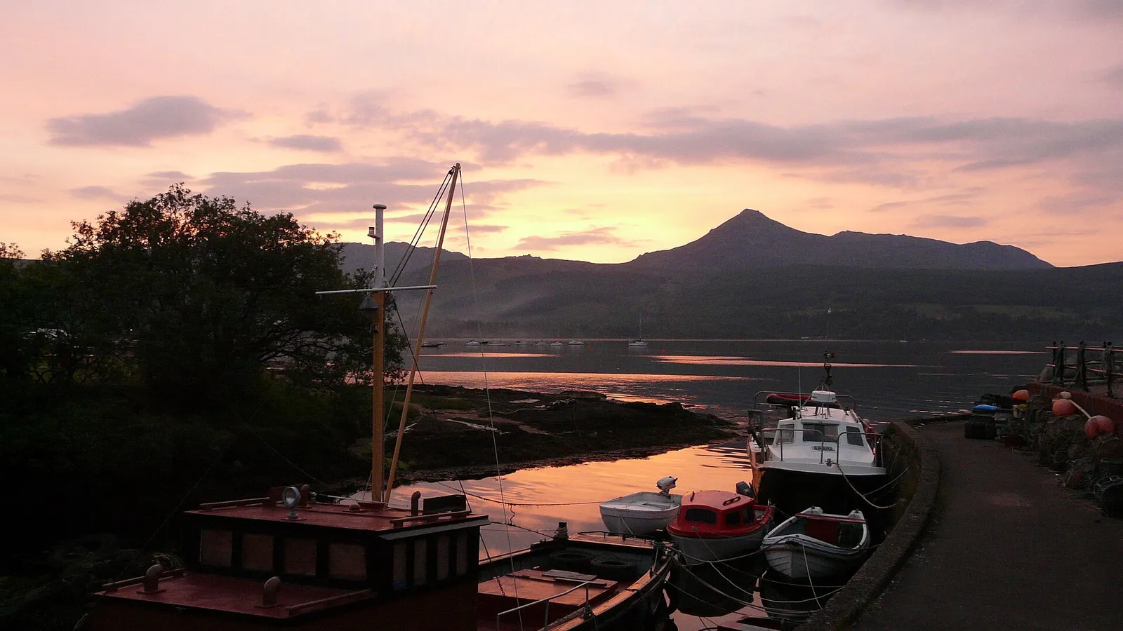

Isle of Arran
Contents
TL;DR
- established The Highland Boundary Fault runs physically through Arran, dividing it into a granite-mountain north and a sandstone-lowland south — this is a mapped geological fact, confirmed by field survey, not a figure of speech.
- established Geologist James Hutton visited Arran in 1787 and identified an unconformity near Lochranza that became key evidence for his uniformitarian theory of geological time — this is documented history of science with a named figure, date, and location, not folklore.
- disputed The popular tag "Scotland in miniature" is a marketing-friendly summary of Arran's compressed Highland/Lowland geology rather than a term with a single traceable origin or official status, so this article treats it as a useful descriptive label, not an authoritative classification.
- established Nineteenth-century Clearances on Arran, carried out under Alexander, 10th Duke of Hamilton, forcibly displaced islanders, including 86 people who emigrated to Canada aboard the brig Caledonia in 1829 and received only a fraction of the land promised — this is documented, named, dated history and is stated directly.
- established A 2019 LiDAR survey at Machrie Moor revealed around 1,000 previously unrecorded ancient sites, including a cursus monument believed to be a unique surviving example in Britain — this is recent, published archaeological survey data, not legend.
Key Facts
- Location/Region
- Firth of Clyde, off the coast of Ayrshire, southwest Scotland
- Scale
- 43,201 hectares (167 sq mi); Scotland's 7th-largest island. Goat Fell: 875 m (2,871 ft)
- Type
- Island — mountainous north, lowland agricultural south, divided by the Highland Boundary Fault
- Protected/heritage status
- Brodick Castle (National Trust for Scotland); Machrie Moor stone circles (Historic Environment Scotland, scheduled monuments); multiple SSSIs for geology and wildlife
- Managed/owned by
- Mixed private estates and farms; National Trust for Scotland (Brodick Castle and country park); Forestry and Land Scotland holdings
- Access notes
- Caledonian MacBrayne ferries: Brodick–Ardrossan (main route) and Lochranza–Claonaig (seasonal); no bridge or fixed link to the mainland
Scottish Impact Index (SI Score)
- National Significance
- 8/10
- Historical Continuity
- 9/10
- Human & Economic Importance
- 8/10
- Landscape / Architectural Distinctiveness
- 10/10
- Cultural & Historical Legacy
- 9/10
- Recognition
- 9/10
53/60
Ranked =26th of 43 in Locations
A Note on Claims and Evidence
Arran's geology and population statistics are documented, drawn from geological survey, census data, and institutional record. James Hutton's 1787 visit and his use of the Lochranza unconformity in developing uniformitarian theory are likewise documented history of science, with a named individual, date, and surviving written account. By contrast, the phrase "Scotland in miniature" is best understood as traditional/promotional shorthand — an accurate-enough descriptive summary of the island's geological variety, but not a scientific classification or a phrase with one verifiable point of origin, and this article treats it accordingly rather than as an official designation.
Timeline
Arran's rocks record an exceptionally wide span of geological history compressed into a small area, spanning from ancient metamorphic basement rock to much younger igneous intrusions.
Machrie Moor and surrounding areas settled and monumentalised; stone circles and other ceremonial structures erected.
A LiDAR survey of Machrie Moor identifies around 1,000 previously unrecorded ancient sites, including a cursus monument considered a unique surviving British example.
Brodick Castle's earliest structure established, beginning its long history as a fortified seat on the island.
James Hutton visits Arran and identifies the Lochranza unconformity, providing crucial field evidence for his theory of deep geological time.
Highland Clearances reach Arran under the Dukes of Hamilton's estate management, with widespread tenant displacement.
86 Arran islanders emigrate to Canada aboard the brig Caledonia, receiving far less land on arrival than had been promised.
Brodick Castle passes through the Hamilton family and eventually to the National Trust for Scotland.
Census records Arran's resident population at 4,618.
The new dual-fuelled ferry MV Glen Sannox enters service on the Brodick–Ardrossan route.
Details
A whole country's geology in one small island
Arran's defining natural feature is geological compression: within a modestly sized island of 167 square miles, the Highland Boundary Fault physically separates a mountainous granite north — dominated by Goat Fell at 875 metres — from a gentler sandstone lowland in the south. This is not a loose comparison; the fault is mapped and traceable on the ground, and it is the same structural line that divides Highland from Lowland Scotland across the entire country, here compressed into a single walkable island. The popular description of Arran as "Scotland in miniature" draws its genuine accuracy from exactly this fact: a visitor can observe, within a single day's travel, rock types and landscape forms that elsewhere in Scotland are separated by well over a hundred miles.
This geological variety is what drew James Hutton to Arran in 1787. At Lochranza, Hutton identified a striking unconformity — a boundary where older, tilted rock layers are overlain by much younger horizontal strata, demonstrating an immense, previously unappreciated span of geological time between the two. The site became one of the pieces of field evidence underpinning Hutton's uniformitarian theory, the idea that the Earth's surface has been shaped by slow, continuous natural processes over vast timescales rather than sudden catastrophic events — a foundational shift in how geological time itself came to be understood. Arran's unconformities and igneous features remain studied and visited by geologists and geology students for exactly this reason.
Neolithic monuments and a transformed understanding of the landscape
Long before Hutton's visit, Arran's Machrie Moor was already a significant ceremonial landscape, with surviving stone circles among its most visible prehistoric monuments. What has changed dramatically is the scale of what is known to survive beneath the visible surface: a 2019 LiDAR (laser scanning) survey of Machrie Moor identified approximately 1,000 previously unrecorded ancient features, including a cursus monument — a long, rectangular ceremonial earthwork — believed to be a uniquely complete surviving example of its kind in Britain. This finding substantially expanded the known scale of Neolithic activity on Arran and is a reminder that even well-studied heritage landscapes can still hold major undiscovered archaeology, revealed only by modern remote-sensing technology rather than excavation alone.
Clearance, emigration, and a diminished population
Arran's social history in the nineteenth century follows a pattern familiar across the Highlands and Islands, and this article states it without euphemism. Under the estate management of Alexander, 10th Duke of Hamilton, tenant communities on Arran were forcibly displaced during the Highland Clearances, as landholdings were reorganised, often in favour of large-scale sheep farming, at the direct cost of existing small tenant farmers. In 1829, 86 Arran islanders emigrated to Canada aboard the brig Caledonia — a documented, dated departure — only to receive, on arrival, a fraction of the land that had reportedly been promised to them, a mere 41 hectares rather than what settlers had been led to expect. This is not an isolated anecdote; it exemplifies the broader pattern of Highland emigration schemes that combined coerced displacement at home with inadequate provision abroad. Arran's population today, at 4,618 at the 2022 census, remains a fraction of its pre-Clearance level, and that demographic shrinkage is a direct, documented legacy of this period rather than simply a feature of island life.
Brodick Castle and built heritage
Brodick Castle, with origins reaching back to the 13th century, is Arran's most prominent built landmark, having passed through the Hamilton family before eventual transfer to the National Trust for Scotland, which now manages the castle and its surrounding country park. Its visibility extends well beyond the island itself: the castle has appeared on the Royal Bank of Scotland's £20 banknote, a reflection of its status as one of Scotland's recognisable historic houses. Its history, inevitably, is entangled with the same Hamilton estate management responsible for the island's Clearance-era displacements — a point worth holding in mind when the castle is presented purely as a picturesque heritage attraction.
Arran today: ferries, tourism, and island identity
Arran has no bridge or fixed link to the mainland; all access runs through Caledonian MacBrayne ferry services, principally the Brodick–Ardrossan crossing, supplemented by a seasonal Lochranza–Claonaig route to Kintyre. The fleet modernised further with the January 2025 introduction of the dual-fuelled MV Glen Sannox, itself part of a long-running and much-publicised saga of ferry delays affecting Clyde and Hebridean routes generally — a modern infrastructure story distinct from, but occasionally conflated with, the island's older heritage narrative. Today Arran markets itself heavily around the "Scotland in miniature" concept, combining geological tourism (walking Hutton's unconformity sites, climbing Goat Fell), prehistoric heritage at Machrie Moor, and country-house heritage at Brodick Castle into a single, compact visitor landscape — while its much-reduced resident population and persistent rural depopulation pressures remain a quieter, less marketed, but equally real part of the island's modern story.
Gaelic on Arran
established Arran was a Gaelic-speaking island until the twentieth century, with a language divide between its two sides. The historical geographer Charles Withers, in Gaelic in Scotland 1698–1981 (1984), quotes Martin Martin, who found in 1703 that Gaelic prevailed on the west side of the island and English on the east. In 1793 the minister of Kilmory wrote that Gaelic was "universally spoken". By 1840 English was "rapidly gaining ground" in the village of Kilbride, among settlers from the mainland and the young, while in Kilmory nearly everyone under thirty understood English "but still the Gaelic continues the language of common conversation". Withers notes that Gaelic lasted longest in Kilmory, on the west of the island.
Did You Know?
- Arran's Highland Boundary Fault is the very same geological line that separates the Scottish Highlands from the Lowlands across the entire country — here it runs straight through a single small island.
- James Hutton's 1787 visit to Lochranza produced evidence central to the modern scientific understanding of deep geological time.
- A 2019 laser-scanning survey revealed around 1,000 previously unknown ancient sites at Machrie Moor, including a cursus monument believed unique in Britain.
- In 1829, 86 Arran islanders emigrated to Canada and received only 41 hectares of land on arrival, far less than promised.
- Brodick Castle has appeared on the Royal Bank of Scotland's £20 note.
- Arran's 2022 census population, 4,618, is a small fraction of its pre-Clearance numbers.
- The island has no bridge to the mainland; all access is by Caledonian MacBrayne ferry.
- Arran is Scotland's 7th-largest island by area, despite its outsized geological and tourism profile.
FAQ
1Why is Arran called "Scotland in miniature"?
Because the Highland Boundary Fault runs through the island, producing both Highland-style granite mountains in the north and Lowland-style sandstone farmland in the south within a small area — though the phrase itself is a popular descriptive label rather than an official designation.
2What is Goat Fell?
Arran's highest peak, at 875 metres, dominating the island's mountainous north.
3Why is Arran important to geology?
James Hutton's 1787 study of an unconformity at Lochranza provided key evidence for the modern understanding of deep geological time.
4Were people forced off Arran?
Yes — documented Highland Clearances under the Dukes of Hamilton's estate management displaced tenant communities in the nineteenth century, including islanders who emigrated to Canada in 1829.
5How do you get to Arran?
By Caledonian MacBrayne ferry, mainly from Ardrossan to Brodick, with a seasonal second route from Lochranza to Claonaig.
6What is Machrie Moor?
A Neolithic ceremonial landscape with surviving stone circles, now known from LiDAR survey to contain far more ancient sites than previously recorded.
7Is Brodick Castle open to visitors?
Yes, it is managed by the National Trust for Scotland along with its surrounding country park.
8What is Arran's population?
4,618 residents at the 2022 census.
9Is there a bridge to Arran?
No, there is no fixed link; all travel to and from the island is by ferry.
10What rock types can you see on Arran?
Granite in the mountainous north and sandstone in the lowland south, with a range of other igneous and sedimentary features in between.
11Did everyone leave Arran during the Clearances?
No, but the population was substantially reduced through forced displacement and emigration, a legacy still visible in today's much smaller resident population.
12What is the cursus monument found at Machrie Moor?
A long, rectangular Neolithic ceremonial earthwork, identified via a 2019 LiDAR survey and believed to be a uniquely complete surviving example of its type in Britain.
Sources and Further Reading
Primary/Institutional
- National Trust for Scotland — Brodick Castle and Country Park
- Historic Environment Scotland — Machrie Moor scheduled monuments
- UNESCO/Global Geoparks — Arran geology factsheet
Scholarly/Critical
- Published geological literature on the Lochranza unconformity and Hutton's uniformitarian theory
- Archaeological reporting on the 2019 Machrie Moor LiDAR survey
- Charles W. J. Withers, Gaelic in Scotland 1698–1981: The Geographical History of a Language (John Donald, 1984; ebook Birlinn, 2021)
General
- Wikipedia — "Isle of Arran"
- Arran Wildlife — natural history and geology overview
- National Records of Scotland — 2022 census data for Arran
Caveats: Myths and Disputed Claims
- Misconception: "Scotland in miniature" is an official designation. It is a popular, broadly accurate descriptive label, not an official geological or governmental designation.
- Myth: the 1829 emigrants received the land they were promised. Documented accounts record that they received only a fraction (41 hectares) of the expected land on arrival in Canada.
- Myth: Machrie Moor's archaeology was fully known before 2019. The LiDAR survey substantially expanded the known record, revealing roughly 1,000 previously unrecorded features.
- Context: Brodick Castle. Its ownership history is directly connected to the same Hamilton estate responsible for Clearance-era displacement on the island.
Finished reading? Try the Fact Machine: three reels, one surprising Scottish connection →
Card 025 · Locations