
Assynt & the Northwest Highlands
Contents
Legend/Myth Opener
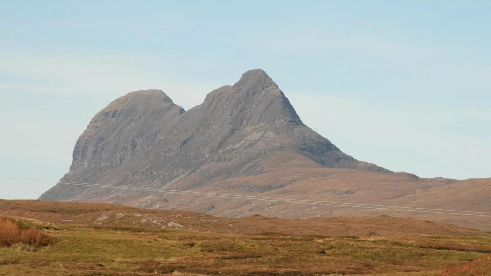
Assynt's isolated peaks are often described simply as "ancient," a word so overused in Highland tourism writing that it loses meaning. The Lewisian gneiss that underlies much of this landscape is not vaguely old but documented at more than three billion years in age — among the oldest rock exposed anywhere in Europe — while the dramatic standalone mountains rising from it, such as Suilven and Quinag, are made of entirely different, much younger rock that has simply resisted erosion better than the gneiss around it. The landscape's drama comes from this geological mismatch, not from uniform antiquity.
TL;DR
- established The Lewisian gneiss exposed across much of Assynt dates to more than three billion years old, among the oldest rock in Europe, confirmed by radiometric dating — stated precisely because "ancient" alone understates just how extreme this age actually is.
- established The iconic standalone peaks of Assynt, including Suilven, Canisp, and Stac Pollaidh, are made of much younger Torridonian sandstone (and in places quartzite) sitting on top of the far older gneiss, meaning the landscape's two main rock types differ in age by well over two billion years — this is stated directly because the peaks are often described as "ancient" without noting they are geologically much younger than the ground they sit on.
- established The Moine Thrust, identified in Assynt by pioneering geologists Ben Peach and John Horne in the late 19th century, was a foundational discovery in the development of modern structural geology — stated directly because this remote landscape is a genuine site of major international scientific significance, not simply scenic backdrop.
- established In 1993, crofters in North Assynt formed Scotland's first community buyout of this kind, purchasing the North Lochinver Estate themselves after it was put up for sale — this is stated directly because it marks a genuinely significant moment in modern Highland land reform, not simply local news.
- traditional Assynt's 13 crofting townships trace their present form to displacement during the Highland Clearances, well documented in estate and land records, though the precise experience of individual communities during that period is not uniformly recorded in equal detail across every township.
Key Facts
- Location/Region
- Assynt parish, south-west Sutherland, Highland, Scotland
- Height/Area/Scale
- Suilven: 731 m; Canisp: 846 m; Quinag: 808 m; Ben More Assynt: 998 m (the area's highest point); population around 989 (2001 census)
- Geology/Formation
- Lewisian gneiss (more than 3 billion years old) forms the underlying "basement"; isolated peaks of Torridonian sandstone (c. 1 billion years old), some capped with quartzite, rise dramatically above it; the Moine Thrust Belt along the eastern edge is a major structural geology feature
- Protected status
- Part of the North West Highlands UNESCO Global Geopark; Knockan Crag National Nature Reserve; multiple SSSI designations for geological and ecological interest
- Managed/Owned by
- Substantial community ownership via the Assynt Crofters' Trust (North Assynt Estate, from 1993) and the Assynt Foundation (Glencanisp and Drumrunie estates, from 2005); remaining land in mixed private estate ownership
- Access notes
- Suilven, Quinag, and Stac Pollaidh all have marked walking routes but involve steep, pathless, or exposed sections; the region is remote with limited settlement and services, requiring self-sufficient trip planning
Scottish Impact Index (SI Score)
- National Significance
- 8/10
- Historical Continuity
- 10/10
- Human & Economic Importance
- 5/10
- Landscape / Architectural Distinctiveness
- 10/10
- Cultural & Historical Legacy
- 9/10
- Recognition
- 7/10
49/60
Ranked =34th of 43 in Locations
A Note on Claims and Evidence
Claims are tiered as documented (the radiometric dating of Lewisian gneiss and Torridonian sandstone, the Moine Thrust's scientific history, the 1993 and 2005 community land buyouts, current protected-area status), traditional (long-standing local history around specific crofting townships and clan-era castle sites, broadly well supported but not always documented to the same evidentiary standard in every individual case), and legend-myth (claims with no solid evidential basis, including some place-name folklore and the common but geologically imprecise habit of calling the whole landscape uniformly "ancient" without distinguishing its very differently aged rock layers).
Timeline
The Lewisian gneiss that underlies much of Assynt forms, through repeated episodes of deep metamorphism, among the oldest rock sequences exposed anywhere in Europe.
Torridonian sandstone is deposited on top of the eroded, much older gneiss surface, later forming the resistant cap rock of peaks such as Suilven and Canisp.
Glaciers strip away softer surrounding rock, leaving the harder Torridonian sandstone peaks standing dramatically isolated above the gneiss lowlands — a landform type known as inselbergs.
The region falls within the territory of Clan MacLeod of Assynt, with Ardvreck Castle on Loch Assynt serving as a clan stronghold.
Assynt's communities are substantially displaced during the Highland Clearances, as commercial sheep farming and sporting estates reorganise land use; thirteen crofting townships are established in the resulting settlement pattern.
The Hector sails from Loch Broom for Pictou, Nova Scotia, with almost 200 Highlanders from Ross-shire and Sutherland.
Norman McLeod is born at Point of Stoer in Assynt.
McLeod sails from Loch Broom for Pictou; followers from Assynt and Ullapool go with or after him.
McLeod's community settles at St Ann's, Cape Breton Island.
Six ships carry more than 800 of McLeod's followers from Cape Breton to Australia; most move on to Waipu, New Zealand.
Geologists Ben Peach and John Horne identify and map the Moine Thrust Belt in Assynt, a discovery that helps found modern structural geology, commemorated today by a cairn at Inchnadamph.
Crofters form the Assynt Crofters' Trust after the North Lochinver Estate is put up for sale, raising over £130,000 from more than 800 individual donors alongside government support to purchase the estate, completing the sale on 1 February 1993 as the North Assynt Estate.
The Assynt Foundation completes a further community buyout of the Glencanisp and Drumrunie estates, bringing roughly 18,000 hectares into local community ownership.
Assynt forms part of the North West Highlands UNESCO Global Geopark, recognised internationally for its geological significance.
Details
Geological formation
Assynt presents one of the clearest and most studied examples anywhere in the world of a landscape built from radically mismatched geological ages sitting side by side. Its deep foundation is Lewisian gneiss, a metamorphic rock formed through repeated episodes of intense heat and pressure deep within the Earth's crust more than three billion years ago — making it among the oldest rock exposed anywhere in Europe, roughly two-thirds the age of the Earth itself. This ancient gneiss forms the low, undulating, loch-studded terrain across much of Assynt. Rising abruptly from that ancient surface, however, are the region's famous standalone mountains — Suilven, Canisp, Quinag, Stac Pollaidh, and others — and these are made of an entirely different, far younger rock: Torridonian sandstone, deposited roughly a billion years ago on top of the already ancient and eroded gneiss surface, in places capped further by resistant quartzite. The dramatic, isolated "island mountain" or inselberg profile of these peaks is a direct consequence of this geological layering combined with much more recent glacial erosion: as Ice Age glaciers scoured the landscape, they stripped away softer surrounding material far more readily than the hard, resistant sandstone and quartzite caps, leaving these peaks standing as steep, visually startling outliers above the surrounding gneiss lowland, rather than as part of a continuous mountain range. Along Assynt's eastern margin runs the Moine Thrust Belt, a zone where older rock has been pushed up and over younger rock along a low-angle fault — a structure first mapped and correctly interpreted here by geologists Ben Peach and John Horne in the late 19th century, work that was initially controversial but ultimately became foundational to the modern understanding of mountain-building and crustal deformation worldwide. A cairn at Inchnadamph commemorates their work, and the wider area's recognition as part of the North West Highlands UNESCO Global Geopark rests substantially on this history.
Human history and historical associations
Human settlement in Assynt reaches back into prehistory, but its documented clan-era history centres on Clan MacLeod of Assynt, whose stronghold, Ardvreck Castle on the shore of Loch Assynt, remains a visible ruin today. Like much of the Highlands, Assynt's settlement pattern was profoundly reshaped during the 18th and 19th centuries by the Highland Clearances, as landowners reorganised estates around commercial sheep farming and later sporting use, displacing earlier subsistence communities; the resulting pattern of thirteen crofting townships across the estate reflects this reorganisation rather than an unbroken continuity from earlier settlement. What distinguishes Assynt's modern history within the wider Highlands is its place at the forefront of community land reform. In 1992, when the North Lochinver Estate — covering much of North Assynt — was put up for sale, the resident crofters organised as the Assynt Crofters' Trust and, through a public fundraising appeal that drew donations from more than 800 individuals alongside government support, purchased the estate themselves in February 1993, becoming one of the earliest and most influential community land buyouts in modern Scottish history and a direct precursor to the land reform legislation that followed in subsequent decades. A further buyout in 2005, through the Assynt Foundation, brought the neighbouring Glencanisp and Drumrunie estates — some 18,000 hectares in total — into community ownership as well, meaning a very substantial proportion of Assynt's land is today managed by local community bodies rather than traditional private sporting estates, a genuinely distinctive status within the wider Highlands.
Emigration from Assynt and the north-west
established The north-west coast was a starting point for some of the best-known Highland emigrations. The historian Marjory Harper, in Adventurers and Exiles (2003), describes how the Hector left Loch Broom in July 1773 with almost 200 Highlanders, recruited mainly in Ross-shire and Sutherland by John Ross, a Dingwall merchant, for land at Pictou in Nova Scotia. Eighteen children died on a voyage of about ten weeks, and the ship is now remembered in Pictou as "Canada's Mayflower". In the 1820s and 1830s emigrants from Sutherland were taken by steamer to regional embarkation ports including Lochinver, organised by the Leith agent William Allan and his network of local sub-agents.
established Assynt's most famous emigrant was the preacher Norman McLeod, born at Point of Stoer in 1780. Harper relates that after the minister of Lochbroom blocked his appointment as schoolmaster at Ullapool and stopped his salary for unlicensed preaching, McLeod emigrated in 1817 with followers from Assynt and Ullapool, whom she puts at about 400. The Dictionary of Canadian Biography confirms that he sailed from Loch Broom for Pictou by July 1817. In 1820 his followers built boats to head for Ohio but stopped at St Ann's on Cape Breton Island and settled there; the Dictionary says about 700 people eventually settled at St Ann's. Between 1851 and 1859 six ships carried more than 800 of the community to Australia, and most then moved on to Waipu, north of Auckland. McLeod died there in 1866.
shared Harper treats McLeod as the leading Presbyterian example of a minister leading his people overseas, and calls him "talented but autocratic". Some details differ between sources. Harper describes the 1817 party as about 400 people sailing in "a self-built boat"; the Wikipedia biography says McLeod crossed on the barque Frances Ann and gives no number, and places the self-built vessels later, the schooner Ark in 1820 and the barque Margaret in 1851. Harper puts the Waipu community at about 1,000 by 1860; Wikipedia gives about 883. Her book also gives two different dates for the departure to Australia (1849 in one chapter, 1851 in another); the 1851 date matches the Dictionary of Canadian Biography.
Ecology and distinctive natural features
Assynt's landscape supports a wide range of habitats across its gneiss lowlands, sandstone peaks, and numerous lochs and lochans, including upland heath, blanket bog, and specialist plant communities associated with both the acidic gneiss terrain and the different soil chemistry of the Torridonian sandstone peaks. The area also contains Scotland's longest cave system, Uamh an Claonaite, near Inchnadamph, a product of the limestone geology found locally alongside the dominant gneiss and sandstone. Knockan Crag National Nature Reserve, within the Geopark, offers accessible interpretation of the Moine Thrust and the area's wider geological story for visitors without specialist training.
National identity, recreation, and tourism
Assynt occupies a distinctive niche within Scottish mountain and landscape tourism: its peaks, though individually lower than many Highland Munros, are celebrated specifically for their dramatic isolated profiles and the geological story they tell, drawing hillwalkers, geologists, and photographers specifically for that combination rather than for sheer altitude. The region's recognition as part of the North West Highlands UNESCO Global Geopark formalises this scientific tourism identity, distinct from the mountaineering-focused reputation of landscapes like the Cuillin or Ben Nevis covered elsewhere in this collection. Assynt's community land ownership model has also itself become a point of interest and visitor education, with the Assynt Crofters' Trust and Assynt Foundation's history now actively presented to visitors as part of the area's modern identity, directly linking the landscape's geological story to contemporary questions of who owns and manages Highland land.
Did You Know?
- The Lewisian gneiss underlying much of Assynt is more than three billion years old, roughly two-thirds the age of the Earth itself.
- Suilven and the other famous standalone Assynt peaks are made of Torridonian sandstone around a billion years younger than the ancient gneiss they appear to rise from.
- The Moine Thrust, first correctly mapped in Assynt by geologists Ben Peach and John Horne, became a foundational discovery in the global science of structural geology.
- In 1993, Assynt crofters completed one of the earliest and most influential community land buyouts in modern Scottish history, raising funds from more than 800 individual donors.
- A further community buyout in 2005 brought roughly 18,000 additional hectares around Assynt into local ownership.
- Scotland's longest cave system, Uamh an Claonaite, lies beneath Assynt near Inchnadamph.
- Stac Pollaidh's jagged summit ridge, instantly recognisable in photographs, is a product of its quartzite cap eroding into pinnacles while surrounding rock has worn away far more smoothly.
- The Waipu community in New Zealand descends in large part from Assynt and Ullapool people who followed Norman McLeod by way of Nova Scotia, Cape Breton and Australia.
- Assynt's recognition as part of a UNESCO Global Geopark places it among a select group of landscapes worldwide recognised specifically for outstanding and globally significant geology.
FAQ
1How old is the rock in Assynt?
The Lewisian gneiss is more than three billion years old, among the oldest exposed rock in Europe; the peaks above it are made of much younger Torridonian sandstone, around a billion years old.
2Why do Assynt's mountains look so different from the surrounding land?
Because they are made of a different, more erosion-resistant rock (Torridonian sandstone, sometimes capped with quartzite) than the ancient gneiss lowland around them, so glaciers wore away the surrounding rock far more than the peaks themselves.
3Is Suilven hard to climb?
Yes, relatively — the path is long, remote, and includes a steep, exposed final section; it is a serious hillwalking day rather than a casual outing.
4What is the North West Highlands Geopark?
An internationally recognised UNESCO designation for landscapes of outstanding geological significance, covering Assynt and the surrounding region.
5Who owns the land in Assynt?
A substantial share is owned by local community bodies — the Assynt Crofters' Trust (since 1993) and the Assynt Foundation (since 2005) — alongside remaining private estates.
6What was the Assynt Crofters' Trust buyout?
In 1993, crofters raised funds and purchased the North Lochinver Estate themselves after it was put up for sale, one of the earliest major community land buyouts in modern Scotland.
7What is the nearest town to Assynt?
Lochinver is the main village and service centre within Assynt; Ullapool, further south, is the nearest larger town.
8Is Assynt remote?
Yes — it is sparsely populated (fewer than 1,000 residents across the whole parish) with limited services, and visitors should plan trips with that in mind.
9What is the Moine Thrust?
A major geological fault structure where older rock has been pushed over younger rock, first correctly mapped in Assynt in the late 19th century and foundational to modern structural geology.
10When is the best time to visit Assynt?
Late spring to early autumn for walking conditions; the area is exposed to severe weather in winter and has limited daylight and services at that time of year.
11Can you visit Ardvreck Castle?
Yes — the ruined castle on Loch Assynt is freely accessible and a popular short visit.
12Who was Norman McLeod?
An Assynt-born preacher who left for Nova Scotia in 1817 with followers from Assynt and Ullapool, settled at St Ann's on Cape Breton Island in 1820 and, in the 1850s, led much of that community to Australia and then to Waipu in New Zealand, where he died in 1866.
13Did people emigrate from Assynt during the Clearances?
Yes, though emigration did not always follow eviction directly. McLeod's followers left as a religious community, while other Sutherland emigrants of the 1820s and 1830s sailed from ports such as Lochinver through local agents.
14Does Assynt have any caves open to visitors?
Scotland's longest cave system, Uamh an Claonaite, lies near Inchnadamph, though cave access generally requires appropriate caving experience and permission rather than casual visiting.
Sources and Further Reading
Primary/Institutional
- North West Highlands UNESCO Global Geopark — geology and heritage information
- NatureScot — Knockan Crag National Nature Reserve and SSSI documentation
- Assynt Crofters' Trust and Assynt Foundation — community land ownership history
Scholarly/Critical
- British Geological Survey — Lewisian gneiss and Moine Thrust Belt studies
- Historical geology literature on Ben Peach and John Horne's work in the Northwest Highlands
- Marjory Harper, Adventurers and Exiles: The Great Scottish Exodus (Profile Books, 2003)
Specialist
- Dictionary of Canadian Biography, "McLeod, Norman", https://www.biographi.ca/en/bio/mcleod_norman_9E.html (birth, 1817 voyage, St Ann's, departures 1851–59)
General
- Norman McLeod (minister) — Wikipedia (ships Frances Ann, Ark and Margaret; Waipu population)
- Discover Assynt — geology and landform visitor information
- VisitScotland — Assynt and North West Highlands visitor information
Caveats: Myths and Disputed Claims
- Avoid describing the whole Assynt landscape as uniformly "ancient" without distinguishing the Lewisian gneiss (over 3 billion years old) from the much younger Torridonian sandstone peaks (around 1 billion years old) sitting on top of it — the age gap is itself a key part of the landscape's story.
- Do not present Assynt's land ownership as a single simple "community-owned wilderness"; ownership is a genuine mix of community trusts and remaining private estates, and this mix should be stated accurately rather than simplified in either direction.
- Clan-era narrative details about Ardvreck Castle and Clan MacLeod of Assynt beyond the broadly documented record should be flagged as traditional rather than stated as settled fact.
- The precise individual experience of each of Assynt's thirteen crofting townships during the Clearances is not uniformly documented; avoid presenting a single generalised narrative as applying identically to every township.
- Do not state as fact that Norman McLeod's 1817 party built its own ship or numbered exactly 400; sources differ, and the self-built vessels are better documented for 1820 and 1851.
- Tourism material sometimes implies the Moine Thrust discovery was uncontroversial at the time; historically it was genuinely disputed among geologists before becoming accepted, and this scientific debate is worth noting rather than smoothing over.
Card 017 · Locations