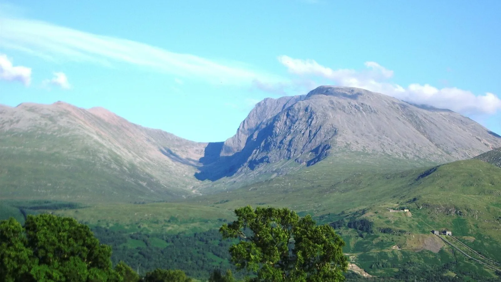

Ben Nevis & Glen Nevis
Contents
Legend/Myth Opener
Ben Nevis is routinely described as "wild" and "untamed" — the ultimate test of raw Highland nature. In fact, the mountain beneath that reputation carries a weather observatory's buried foundations, a century and a half of mountain rescue statistics, a managed conservation estate, and a summit visited by roughly 150,000 people a year via a maintained path. The wildness is real, but it is also one of the most studied, surveyed, and stewarded landscapes in Scotland.
TL;DR
- established Ben Nevis is the highest mountain in the British Isles at 1,345 metres, a fact fixed by modern Ordnance Survey measurement, not folklore.
- established The mountain is the eroded remnant of a Devonian-age volcanic complex roughly 350 million years old, confirmed by field geology on its andesite, granite, and basalt lithologies — this is stated plainly because older guidebooks sometimes reduce it to "an extinct volcano" without the geological nuance of a collapsed caldera later intruded by granite.
- established Over 100 fatalities have been recorded on the mountain since the mid-19th century, a figure worth stating directly because the "gentle tourist path" image of the Pony Track obscures how exposed the summit plateau becomes in poor visibility or winter conditions.
- traditional The name "Nevis" is popularly glossed as deriving from Gaelic for "malicious" or "venomous," a folk etymology repeated often enough that it needs flagging as unproven rather than settled.
- established Since 2000 the south side and summit have been owned and managed by the John Muir Trust, a conservation charity — this is stated directly because it corrects the common assumption that Scotland's highest mountain sits on anonymous "wild" land with no active owner or management plan.
Key Facts
- Location/Region
- Lochaber, Highland, Scotland; Glen Nevis runs south and east of Fort William
- Height/Area/Scale
- Ben Nevis summit: 1,345 m (4,413 ft); summit plateau roughly 100 acres; Glen Nevis extends c. 10 km from Fort William
- Geology/Formation
- Devonian-age (c. 350 million years old) collapsed volcanic complex; andesite lavas, granite intrusion, basaltic rock; later heavily glaciated, producing the 700 m north-face cliffs
- Protected status
- Part of the Ben Nevis and Glen Coe National Scenic Area; summit and south flank within a John Muir Trust conservation estate; Site of Special Scientific Interest designations cover parts of the massif for geology and upland habitat
- Managed/Owned by
- John Muir Trust (south side and summit, since 2000); other landholdings in the glen held privately and by Forestry and Land Scotland
- Access notes
- Main ascent via the Mountain Track (Pony Track) from Glen Nevis visitor centre, c. 17 km round trip; CMD Arête and north-face winter/rock routes for experienced mountaineers only; summit plateau navigation hazardous in cloud (present c. 80% of days Nov–Jan); several fatalities most years
Scottish Impact Index (SI Score)
- National Significance
- 9/10
- Historical Continuity
- 8/10
- Human & Economic Importance
- 8/10
- Landscape / Architectural Distinctiveness
- 10/10
- Cultural & Historical Legacy
- 9/10
- Recognition
- 10/10
54/60
Ranked =20th of 43 in Locations
A Note on Claims and Evidence
This article applies a three-tier framework throughout: documented facts are those fixed by survey, geological fieldwork, or primary historical record (the 1,345 m summit height, the Devonian volcanic origin, the 1883–1904 observatory); traditional claims are long-repeated local or etymological lore that lacks a documentary source but is not contradicted by one (place-name derivations, some clan associations with the glen); and legend-myth covers claims with no credible evidential basis, repeated mainly for romantic effect (any suggestion the mountain was "untouched by man" before modern tourism, or folk tales attached to specific crags with no textual root before the 19th-century tourism boom). Readers should treat the tiering in the TL;DR and body text as the operative distinction, not decoration.
Timeline
A volcanic complex forms, collapses as a caldera, and is intruded by granite; this complex is later eroded to become the Ben Nevis massif.
Glaciers carve the north-face corries and cliffs and deepen Glen Nevis into its present U-shaped form.
First recorded ascent of Ben Nevis, by botanist James Robertson, the earliest documented summiting.
A full-time meteorological observatory operates at the summit, generating weather data still referenced today; physicist C.T.R. Wilson's observations of optical phenomena there contributed to his invention of the cloud chamber.
First complete ascent of Tower Ridge, opening the north face to serious mountaineering.
The summit Peace Memorial cairn is erected, commemorating the Second World War.
The John Muir Trust acquires the Ben Nevis Estate, covering the summit and south side, formalising conservation management.
The mountain receives an estimated 150,000 ascents a year via the Mountain Track; it remains part of the Ben Nevis and Glen Coe National Scenic Area and a Site of Special Scientific Interest.
Details
Geological formation
Ben Nevis is not, as sometimes casually stated, a simple "extinct volcano" standing where it erupted. The mountain is the deeply eroded remnant of a Devonian-period volcanic complex, roughly 350 million years old, that underwent caldera collapse — the ground above a drained magma chamber subsided — and was then intruded by granite magma rising into the collapsed structure. Over hundreds of millions of years, erosion stripped away the overlying volcanic material, in places exposing the granite core and in others leaving andesite lavas and ash deposits intact on the flanks. The mountain's structure is consequently a geological cross-section: Carn Mor Dearg granite to the east, andesite and basalt lava sequences making up the summit dome and the dramatic cliffs of the north face. Those cliffs — roughly 700 metres of near-vertical rock, the tallest in the UK — are themselves a product of much more recent sculpting: glaciers of the last Ice Age, which ended around 11,700 years ago, plucked and scoured the volcanic rock into the corries, arêtes, and cliff faces that give the mountain its present dramatic profile. The summit plateau — a flat, boggy expanse of around 100 acres bounded by cliffs on three sides — is itself a product of that glacial erosion acting on the relatively resistant andesite cap.
Human history and historical associations
Human engagement with Ben Nevis as a place to be climbed, rather than simply lived beneath, is a comparatively recent phenomenon. The earliest documented ascent is botanist James Robertson's climb on 17 August 1771, undertaken for scientific collection rather than sport. Mountaineering as recreation developed through the 19th century, culminating in the construction of the Pony Track (today's Mountain Track) in 1883 to service the newly built summit observatory — a full-time meteorological station that operated continuously from 1883 to 1904, staffed year-round in brutal conditions to record weather data that remains scientifically valuable. The observatory's most famous indirect legacy is scientific rather than meteorological: physicist C.T.R. Wilson, struck by the optical halo and glory effects he observed in cloud at the summit, went on to invent the cloud chamber, a device that proved foundational to 20th-century particle physics and earned him a Nobel Prize. Glen Nevis itself, the deep glacial valley running south-east from Fort William towards the mountain's flank, has its own layered history: like much of the Highlands, the glen's population and land use were reshaped by the agricultural and social upheavals of the 18th and 19th centuries, with sheep farming and later sporting estates replacing earlier subsistence settlement patterns — a history that guidebooks celebrating the glen's "wild" scenery frequently omit. In the 20th and 21st centuries the glen has become a favoured filming location, used for Braveheart, Rob Roy, Highlander, and several Harry Potter sequences, adding a layer of invented cinematic mythology on top of the real landscape.
Ecology and distinctive natural features
The Ben Nevis massif supports a range of upland habitats recognised in its Site of Special Scientific Interest designations: montane heath, late snow-bed vegetation communities that persist on the north-facing corries into summer, and populations of arctic-alpine plants that are relict survivors from colder post-glacial conditions. The summit plateau's exposure — fog or cloud cover the top for roughly 80% of days between November and January — creates a genuinely sub-Arctic microclimate at a latitude of only around 56.8°N, a quirk of altitude and exposure rather than northerly position. Glen Nevis below has its own distinct ecology, including Steall Falls, one of Scotland's highest waterfalls, reached via a dramatic gorge path and a wire rope bridge; the falls and surrounding birch and oak woodland support a different, lower-altitude set of species from the summit's montane communities.
National identity, recreation, and tourism
Ben Nevis occupies a singular place in the Scottish and British outdoor imagination as "the roof of Britain," anchoring the Three Peaks Challenge alongside Scafell Pike and Snowdon, and drawing roughly 150,000 ascents a year, the overwhelming majority via the maintained Mountain Track. That popularity sits uneasily alongside the mountain's genuine danger: more than 100 fatalities have been recorded since the mid-19th century, with avalanches, white-out navigation errors on the featureless summit plateau, and underestimated winter conditions among the recurring causes — a toll that complicates any purely celebratory framing of the mountain as a straightforward tourist achievement. Since 2000 the John Muir Trust has owned and actively managed the summit and south side, running path maintenance, erosion control, and conservation grazing programmes that make clear the mountain's "wildness" today is substantially curated rather than untouched. The north face cliffs remain one of the most significant winter climbing and ice climbing venues in Britain, host to routes first opened in the late 19th and early 20th centuries and still developed today.
Did You Know?
- The summit observatory that operated from 1883 to 1904 was staffed year-round, through winters so severe that observers sometimes had to dig themselves out of the building after storms.
- C.T.R. Wilson's invention of the cloud chamber — a device central to the discovery of subatomic particles — was directly inspired by optical effects he witnessed in cloud at the Ben Nevis summit.
- Despite its reputation as Britain's tallest, Ben Nevis is modest by world standards: at 1,345 m it is lower than many peaks tourists climb casually elsewhere, and its danger comes almost entirely from weather and navigation hazard rather than altitude.
- Fog or cloud obscures the summit roughly 80% of the time between November and January, meaning most winter visitors to the top see little beyond a few metres of white-out.
- The 700-metre cliffs of the north face are the tallest in the United Kingdom, taller than the cliffs of many far higher Alpine peaks.
- Glen Nevis has stood in for fictional Scottish and fantastical landscapes in Braveheart, Rob Roy, the Highlander films, and several Harry Potter sequences.
- The summit carries a stone shelter and a war memorial cairn erected in 1945, sometimes called Britain's highest war memorial.
- The John Muir Trust, which has owned the summit since 2000, is named for the Dunbar-born conservationist regarded as a founder of the US National Park movement — a Scottish-American connection distinct from the mountain's own history.
FAQ
1How tall is Ben Nevis?
1,345 metres (4,413 ft), the highest point in the British Isles.
2Is Ben Nevis hard to climb?
The standard Mountain Track is a long, steep hill walk rather than a technical climb, but it is physically demanding, exposed to sudden weather changes, and has resulted in numerous fatalities, mostly from poor preparation, navigation error in cloud, or winter conditions.
3How long does it take to climb Ben Nevis?
Most walkers take 7–9 hours round trip via the Mountain Track; fitness, weather, and daylight all affect this significantly.
4What is the best time of year to climb it?
Late spring to early autumn offers the most stable conditions; winter ascents require mountaineering skills, crampons, and ice axe experience due to snow, ice, and avalanche risk.
5Is Ben Nevis a volcano?
It is the eroded remnant of an ancient volcanic complex that was active around 350 million years ago; it has not been volcanically active in the geologically recent past and poses no eruption risk.
6Who owns Ben Nevis?
The summit and south side have been owned by the conservation charity the John Muir Trust since 2000; other parts of the wider estate are held by various private and public landowners.
7What is Glen Nevis best known for?
Its dramatic glacial scenery, Steall Falls (one of Scotland's highest waterfalls), and extensive use as a film location, alongside being the main approach glen for Ben Nevis ascents.
8Is Glen Nevis safe to walk?
The road and lower paths are accessible to most visitors, but the gorge path to Steall Falls and any route onto the surrounding mountains carry real risk and have caused fatalities; signage at the car park warns of this directly.
9What town is nearest to Ben Nevis and Glen Nevis?
Fort William, at the entrance to Glen Nevis, is the nearest town and main service base.
10Why does Ben Nevis get so much cloud?
Its height, position close to the Atlantic, and exposure to moist westerly weather systems combine to produce cloud cover on the summit roughly 80% of the time between November and January.
11Can you drive up Ben Nevis?
No; there is no public road to the summit. A public road runs part way into Glen Nevis, but the mountain itself is accessed only on foot (or, for the observatory era, by pony).
12Is there anything at the summit?
A ruined observatory building, a trig point, a war memorial cairn, and an emergency shelter; there are no shops or permanent facilities.
Sources and Further Reading
Primary/Institutional
- John Muir Trust — Ben Nevis Estate conservation and management information
- NatureScot — Site of Special Scientific Interest and National Scenic Area documentation for Ben Nevis and Glen Coe
- Highland Council / High Life Highland — Ben Nevis Visitor Centre geology resources
Scholarly/Critical
- British Geological Survey regional guides to the geology of the Grampian Highlands and the Ben Nevis volcanic complex
- Peer-reviewed glaciological and geomorphological studies of Highland corrie and arête formation
General
- Ben Nevis — Wikipedia
- Glen Nevis — Wikipedia
- VisitScotland — Ben Nevis and Glen Nevis visitor information
- Scottish mountaineering and rescue association incident reporting (Mountain Rescue Scotland)
Caveats: Myths and Disputed Claims
- Do not state Ben Nevis is simply "an extinct volcano standing where it erupted" — it is a deeply eroded remnant of a collapsed volcanic complex, substantially reshaped by later glaciation; the correct phrasing is "the eroded remains of a Devonian volcanic complex."
- The Gaelic etymology of "Nevis" as meaning "malicious," "venomous," or "terrible" is a popular but linguistically contested gloss; present it as traditional/disputed, not settled fact.
- Avoid describing the summit plateau or wider mountain as "untouched" or "pristine wilderness" — it carries an active path network, erosion-control works, ruined observatory structures, and managed conservation grazing under the John Muir Trust.
- The claim that Ben Nevis is among the most dangerous mountains "in the world" is an overreach; it is dangerous primarily due to weather volatility and visitor volume relative to its accessibility, not technical difficulty or altitude compared to major world ranges.
- Clan and folklore tales attached to specific crags or corries on Ben Nevis with no documentary root before 19th-century tourism writing should be flagged as legend-myth, not repeated as settled local history.
Card 011 · Locations