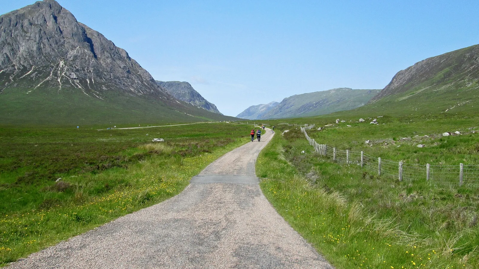

Glen Coe
Contents
Legend/Myth Opener
Glen Coe is often presented as simply the stage for a single night of 17th-century treachery — "the Massacre of Glencoe" standing in for the whole glen's identity. The real history is both older and more structurally political than the popular story of a lone act of Campbell savagery against innocent MacDonalds: it is a 420-million-year-old volcanic caldera reshaped by Ice Age glaciers, and the 1692 killings were a state-ordered act of policy, carried out by a mixed-command Crown regiment, inside a specific legal and clan feud context that the "ancient blood feud" framing tends to flatten.
TL;DR
- established Glen Coe formed from the collapse of a volcanic caldera roughly 420 million years ago, a geological fact confirmed by mapped ring faults and intrusive rock sequences, not merely dramatic scenery description.
- established On 13 February 1692, Crown soldiers billeted among the MacDonalds of Glencoe killed approximately 38 men, with further women and children dying of exposure after their homes were burned — the death toll is stated precisely here because popular retellings often inflate or vaguely gesture at the numbers.
- established The killings were authorised in writing up the chain of command to Secretary of State John Dalrymple and countersigned by King William III, making this a state action rather than a spontaneous clan vendetta — this is stated directly because "ancient Highland blood feud" framing obscures the government's direct responsibility.
- traditional The massacre is widely remembered as a uniquely treacherous breach of Highland hospitality, since the soldiers had been guests in MacDonald homes for nearly two weeks before the killings — this framing is well-supported by contemporary accounts but its emotional weight has sometimes overshadowed the equally important chain-of-command facts.
- established Most of the glen has been owned by the National Trust for Scotland since 1935, and it holds National Nature Reserve, Special Area of Conservation, and National Scenic Area status today — stated directly because the glen's "untamed wilderness" image coexists with more than eighty years of organised conservation ownership.
Key Facts
- Location/Region
- Lochaber, Highland, Scotland, on the A82 between Crianlarich and Fort William
- Height/Area/Scale
- Glen covers c. 56.3 km²; c. 12.5 km long; floor narrower than 700 m in places; peaks include Bidean nam Bian (1,150 m) and Buachaille Etive Mòr (1,022 m)
- Geology/Formation
- Subsidence caldera from a supervolcano active c. 420 million years ago (Silurian/Devonian boundary); later deeply carved by Ice Age glaciers into a classic U-shaped valley
- Protected status
- National Nature Reserve (since 2017); Special Area of Conservation; Site of Special Scientific Interest; within the Ben Nevis and Glen Coe National Scenic Area
- Managed/Owned by
- National Trust for Scotland (most of the glen, purchased 1935 with Scottish Mountaineering Club funds); Glencoe Heritage Trust (MacDonald lands around Invercoe, acquired 2002)
- Access notes
- A82 trunk road runs through the glen; extensive hillwalking and climbing routes (Aonach Eagach, Bidean nam Bian, Buachaille Etive Mòr); Glencoe Ski Centre on Meall a' Bhuiridh in adjoining Glen Etive; many routes are serious scrambles or climbs, not casual walks
Scottish Impact Index (SI Score)
- National Significance
- 10/10
- Historical Continuity
- 9/10
- Human & Economic Importance
- 8/10
- Landscape / Architectural Distinctiveness
- 10/10
- Cultural & Historical Legacy
- 10/10
- Recognition
- 10/10
57/60
Ranked =10th of 43 in Locations
A Note on Claims and Evidence
This article separates documented fact — geological dating of the caldera, the chain of written orders behind the 1692 killings, the confirmed death toll, and current land ownership and protected-area status — from traditional narrative, meaning accounts repeated consistently in early sources and broadly credible but not independently verifiable in every detail (the precise texture of hospitality extended to the soldiers, some individual acts of mercy or refusal among the troops), and from legend-myth, meaning claims with weak or no evidential basis that nonetheless circulate as settled history — chiefly the reduction of the massacre to a simple ancient Campbell-versus-MacDonald blood feud, which understates the Crown's direct political authorship of the killings.
Timeline
A supervolcano in the area erupts and its caldera collapses, forming the geological structure that underlies the glen.
Glaciers carve the caldera remnants into the deep U-shaped valley visible today.
The glen is settled by Clan MacDonald of Glencoe, a branch of Clan Donald, within the wider pattern of Highland clan territories.
The first Jacobite rising breaks out following the deposition of James VII/II; many Highland clans, including the MacDonalds of Glencoe, take part.
Deadline set by King William III's government for clan chiefs to swear an oath of allegiance in exchange for pardon.
Crown soldiers, billeted among the MacDonalds for nearly two weeks, kill approximately 38 men on written orders; women and children subsequently die of exposure after homes are burned.
A Scottish Parliamentary inquiry finds the killings to be murder, chiefly blaming Secretary of State John Dalrymple, while largely sparing the king and leaving most responsible largely unpunished.
The National Trust for Scotland purchases the bulk of the glen using funds raised by the Scottish Mountaineering Club.
The Glencoe Heritage Trust acquires remaining MacDonald-associated land around Invercoe.
Glen Coe is designated a National Nature Reserve, adding to its existing SAC, SSSI, and National Scenic Area protections.
Details
Geological formation
Glen Coe's dramatic topography is the product of two very different geological episodes separated by hundreds of millions of years. The deeper structure is a subsidence caldera: around 420 million years ago, during a period of intense volcanic activity in what is now the Scottish Highlands, a large volcano's magma chamber emptied explosively, and the ground above it collapsed inward along a roughly circular ring fault. Molten rock was then forced upward along that fracture, producing the complex sequence of rhyolite, andesite, and granite intrusions geologists still map in the glen's walls today. This caldera structure is one of the best-preserved and most studied examples in Britain, and the Scottish Geology Trust and British Geological Survey both treat Glen Coe as a textbook site for caldera geology. The valley's present form, however, owes far more to much more recent events: repeated glaciations through the Pleistocene, with the last ice sheet retreating around 11,700 years ago, scoured the ancient volcanic rock into the glen's characteristic steep-sided, flat-floored U-shape, deepening it well beyond anything the original volcanic collapse alone would have produced. The famous individual peaks — the pyramidal Buachaille Etive Mòr standing sentinel at the glen's eastern entrance, the complex multi-top massif of Bidean nam Bian, and the narrow, exposed ridge of Aonach Eagach along the glen's north side — are all products of this combined volcanic-then-glacial history.
Human history and the Massacre of Glencoe
Glen Coe was, for centuries before it became famous for one night's violence, the home territory of Clan MacDonald of Glencoe, a branch of the wider Clan Donald. The event that defines the glen's reputation — the Massacre of Glencoe — deserves to be told with more structural precision than the popular "ancient blood feud" shorthand usually allows. Its origins lie in the political aftermath of the 1688–89 Glorious Revolution: when William III and Mary II displaced the Stuart King James VII/II, many Highland clans, including the MacDonalds of Glencoe under their chief Alasdair MacIain, supported the Jacobite cause in the 1689 rising. Following the rising's collapse, William's government offered pardons to clans that swore an oath of allegiance by 1 January 1692. MacIain attempted to comply but was delayed — partly by winter conditions and partly, documented sources suggest, by deliberate administrative obstruction — and ultimately swore the oath a few days late, to the wrong official. Secretary of State John Dalrymple, Master of Stair, used this technical lateness as pretext to authorise a punitive action explicitly intended to "extirpate" the clan as a warning to others. Soldiers of the Earl of Argyll's Regiment, commanded by Captain Robert Campbell of Glenlyon, were billeted among the MacDonalds for nearly two weeks under the normal Highland obligations of hospitality to guests — accepting food, drink, and lodging, with officers reportedly playing cards with the men they would kill the following night. On the morning of 13 February 1692, on explicit written orders passed down the chain of command and ultimately countersigned by the king, the soldiers killed approximately 38 MacDonald men in their homes or while fleeing; an unknown further number of women and children died of exposure in the snow after their houses were burned. The killing's breach of the sacred Highland duty of hospitality to a guest — "murder under trust" in contemporary Scots legal language — made it unusually shocking even by the standards of a violent era, and a 1695 Parliamentary inquiry formally ruled it murder, though it placed blame chiefly on Dalrymple and left almost nobody meaningfully punished. The event is correctly understood not as an ancient clan-on-clan vendetta reaching back centuries, but as a specific act of state policy carried out through a feudal regimental structure that happened to include Campbell officers and men, set within the immediate political context of post-Revolution Jacobite suppression.
Ecology and distinctive natural features
Beyond its human history, Glen Coe supports a varied range of habitats across its altitude gradient: birch and oak woodland and wet scrub on the lower slopes, blanket bog and moorland dominated by heather, bog myrtle, and cotton grass across the mid-levels, and sparse but ecologically significant alpine and sub-alpine plant communities on the higher ridges and summits, relicts of colder post-glacial conditions. The glen is a stronghold for golden eagle, ptarmigan, and snow bunting, alongside more common upland species such as buzzard, and (notoriously, to visitors) a substantial population of Highland midges in summer. Its combination of SAC and SSSI status reflects both this habitat diversity and the geological significance of the caldera exposures themselves.
National identity, mountaineering, and tourism
Glen Coe is widely regarded, with real justification, as the home of Scottish mountaineering: 19th- and 20th-century climbers developed many of Britain's classic rock and winter routes on Buachaille Etive Mòr, Bidean nam Bian, and the Aonach Eagach ridge, and the National Trust for Scotland's 1935 purchase of the glen was itself funded substantially by the Scottish Mountaineering Club, tying conservation ownership directly to the climbing community. The Glencoe Ski Centre, Scotland's oldest ski area, operates nearby on Meall a' Bhuiridh. The A82 road through the glen is consistently ranked among Scotland's most scenic drives, and the glen's visual drama has made it one of the country's most filmed landscapes, appearing in Monty Python and the Holy Grail, several Harry Potter instalments, and Skyfall. That cinematic and tourist-brochure romance sits, deliberately and sometimes uncomfortably, alongside the glen's documented history of state violence — a juxtaposition the site's own visitor centre and the National Trust for Scotland now address directly rather than smoothing over.
Did You Know?
- The caldera that underlies Glen Coe is one of the best-preserved examples of its kind in Britain, used as a teaching site for geology students studying volcanic collapse structures.
- The Massacre of Glencoe's chain of command ran all the way to King William III, who signed and countersigned the operational orders — this was state policy, not a rogue act.
- Some soldiers refused to carry out the killings; two lieutenants reportedly broke their own swords rather than comply.
- The National Trust for Scotland's 1935 purchase of the glen was funded in part by the Scottish Mountaineering Club, linking the glen's conservation history directly to its climbing community.
- Glen Coe's Buachaille Etive Mòr, often photographed as the archetypal lone Highland peak, actually sits at the boundary between Glen Coe and neighbouring Glen Etive.
- The ski centre at Glencoe, operating on Meall a' Bhuiridh, is Scotland's oldest, predating most other Scottish ski developments.
- The glen's floor narrows to under 700 metres in places, part of why it feels so enclosed and dramatic despite its modest overall scale.
- The 1695 Parliamentary inquiry into the massacre ruled the killings murder but resulted in almost no punishment for those responsible — only the Earl of Breadalbane was briefly imprisoned, and on an unrelated treason charge.
FAQ
1What happened in the Massacre of Glencoe?
On 13 February 1692, government soldiers billeted among the MacDonalds of Glencoe killed around 38 men on explicit written orders, with further women and children dying of exposure after their homes were burned.
2Was the massacre a Campbell versus MacDonald clan feud?
Not primarily — it was a state-authorised punitive action against the MacDonalds for lateness in swearing an oath of allegiance, carried out through a regiment that happened to be commanded by a Campbell officer; the order came from the government, not from Clan Campbell as an institution.
3How was Glen Coe formed?
Through the collapse of a volcanic caldera around 420 million years ago, later deepened and shaped into its present U-shaped valley by glaciers during the last Ice Age.
4Who owns Glen Coe today?
Most of the glen has been owned and managed by the National Trust for Scotland since 1935; the Glencoe Heritage Trust holds adjoining MacDonald-associated land acquired in 2002.
5Is Glen Coe a National Park?
No — it is a National Nature Reserve and National Scenic Area, with SAC and SSSI protections, but it sits within the wider Lochaber area rather than inside a formally designated National Park.
6What are the best walks in Glen Coe?
Options range from easy valley-floor paths suitable for most visitors to serious scrambles like the Aonach Eagach ridge and climbs on Bidean nam Bian, which require mountaineering experience, good weather judgement, and proper equipment.
7Is Glen Coe safe to visit?
The main road and valley-floor viewpoints are accessible and safe for any visitor; the surrounding mountains are genuinely serious terrain with a long history of fatalities among underprepared walkers and climbers, especially in winter.
8What is the nearest town to Glen Coe?
Glencoe village and Ballachulish sit at the glen's western end; Fort William, a larger service town, is a short drive away.
9When is the best time to visit Glen Coe?
Late spring through early autumn for reliable walking conditions and long daylight; winter brings dramatic snow scenery and serious ice climbing but requires appropriate skills and equipment.
10Can you visit the massacre sites?
The Glencoe Folk Museum and National Trust for Scotland visitor centre interpret the massacre's history; physical sites associated with the killings are within the inhabited glen rather than marked as a single discrete monument.
11Why is Glen Coe called the "home of Scottish mountaineering"?
Many of Scotland's earliest and most significant rock and winter climbing routes were pioneered here from the late 19th century onward, and the Scottish Mountaineering Club was instrumental in securing the glen's conservation ownership.
12Does Glen Coe have a ski resort?
Yes — the Glencoe Ski Centre operates on Meall a' Bhuiridh in the adjoining Glen Etive, Scotland's oldest ski area.
Sources and Further Reading
Primary/Institutional
- National Trust for Scotland — Glen Coe property and massacre history pages
- NatureScot — National Nature Reserve, SAC, and SSSI documentation for Glen Coe
- British Geological Survey / Scottish Geology Trust — Glen Coe caldera geological guides
Scholarly/Critical
- Scottish Geology Trust GeoGuide — "Glen Coe, Lochaber: Scene of an ancient caldera collapse"
- Peer-reviewed volcanological studies of Siluro-Devonian caldera complexes in the Scottish Highlands
- Historical scholarship on the political context of the 1689 Jacobite rising and the 1692 oath of allegiance deadline
General
- Glen Coe — Wikipedia
- Massacre of Glencoe — New World Encyclopedia
- VisitScotland — Glen Coe visitor information
Caveats: Myths and Disputed Claims
- Do not describe the Massacre of Glencoe as a simple "ancient Campbell–MacDonald blood feud" — it was a specific 1692 act of state policy, ordered in writing up to Secretary of State John Dalrymple and King William III, carried out via a regimental structure.
- The precise number of women and children who died of exposure is not fixed in the historical record with the same confidence as the approximately 38 men killed directly; state this distinction rather than citing a single combined death toll as exact.
- Avoid presenting Glen Coe's landscape as "untouched wilderness" — it has been an actively managed conservation property under the National Trust for Scotland since 1935, with associated path, grazing, and land management.
- Some dramatic details repeated in popular retellings (exact dialogue among soldiers and victims, specific acts of individual cruelty beyond what is documented) should be treated as traditional narrative embellishment rather than verified fact.
- Film and tourism marketing sometimes implies Glen Coe is a single continuous "set-piece" landscape; in reality it comprises multiple distinct massifs and glens (Glen Coe proper, Glen Etive) often conflated in casual description.
Card 012 · Locations