
The Flow Country
Contents
Legend/Myth Opener
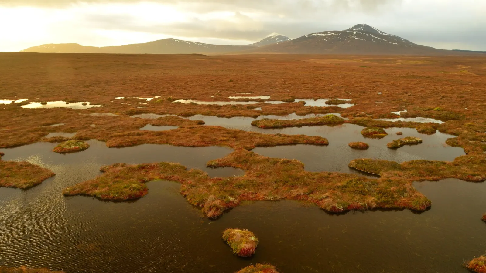
Flat, boggy, and largely treeless, the Flow Country is easy to dismiss as empty or unremarkable land compared with Scotland's mountains and glens. In fact it is the most outstanding example of actively accumulating blanket bog landscape anywhere in the world, holds more carbon per hectare than almost any other ecosystem, and in July 2024 became the world's first peatland to be inscribed as a UNESCO World Heritage Site — a designation that corrects decades during which the land was instead treated, through government tax policy, as suitable ground for commercial conifer plantation.
TL;DR
- established The Flow Country was inscribed as a UNESCO World Heritage Site in July 2024, the first peatland landscape in the world to receive this status — stated precisely because this is a very recent and specific designation, not a long-standing historical one, and the date matters for accuracy.
- established The wider Flow Country covers around 400,000 hectares across Caithness and Sutherland, with the inscribed World Heritage Site covering just under half of that full expanse, at around 187,000 hectares — stated directly because these two figures are easily confused and both appear in different sources.
- established Peat in parts of the Flow Country reaches depths of over 8 metres, and peatlands globally store close to 30% of all land-based carbon despite covering only around 3% of the Earth's land surface — this is stated directly because the Flow Country's climate significance rests on genuinely documented carbon science, not vague "important habitat" framing.
- established Government tax incentives through the 1970s and 1980s actively encouraged commercial forestry companies to drain large areas of the bog and plant non-native conifers, directly damaging the peatland, before tax relief was scrapped in 1988 and restoration efforts since have bought back and felled significant areas of plantation — this history is stated plainly because it is a documented instance of state policy actively harming a landscape later recognised as globally outstanding.
- traditional The Flow Country is often described simply as "wilderness," a framing understandable given its remoteness and low population, but the land has a documented history of past settlement, land use, and the forestry intervention above, meaning "wilderness" should be used carefully rather than implying it was never subject to human activity or management.
Key Facts
- Location/Region
- Caithness and Sutherland, far north Highland, Scotland
- Height/Area/Scale
- Wider Flow Country: c. 400,000 ha; UNESCO World Heritage Site: c. 187,000 ha; peat depth up to and over 8 metres in places
- Geology/Formation
- Blanket bog formed over millennia through accumulation of partially decayed sphagnum moss and other vegetation in a cool, wet, low-relief post-glacial landscape, creating deep peat deposits across a vast, gently undulating area
- Protected status
- UNESCO World Heritage Site (inscribed July 2024); Caithness and Sutherland Peatlands Special Protection Area and Special Area of Conservation (covering roughly 1,500 km²); multiple SSSI designations
- Managed/Owned by
- Mixed ownership including RSPB (Forsinard Flows National Nature Reserve), NatureScot, and private estates; restoration partnerships have bought back and removed significant areas of commercial forestry plantation
- Access notes
- The RSPB Forsinard Flows reserve offers waymarked trails and a viewing tower (the Flows Lookout Tower) suitable for general visitors; much of the wider bog is remote, trackless, and unsuitable for casual walking due to genuine bog hazard
Scottish Impact Index (SI Score)
- National Significance
- 9/10
- Historical Continuity
- 10/10
- Human & Economic Importance
- 7/10
- Landscape / Architectural Distinctiveness
- 10/10
- Cultural & Historical Legacy
- 10/10
- Recognition
- 8/10
54/60
Ranked =20th of 43 in Locations
A Note on Claims and Evidence
Claims here are tiered as documented (the July 2024 UNESCO inscription, the area figures for the wider Flow Country and World Heritage Site, peat depth and global peatland carbon statistics, the 1970s–80s forestry tax incentive history and its 1988 reversal, current ownership and protected-area status), traditional (long-standing characterisation of the area as remote, sparsely populated wild land, broadly accurate but requiring care around the word "wilderness"), and legend-myth (claims with no solid evidential basis, including any suggestion the landscape was untouched by significant human intervention before recent conservation attention, when in fact 20th-century state forestry policy altered substantial areas of it directly).
Timeline
Cool, wet conditions across the flat, low-relief terrain of Caithness and Sutherland allow sphagnum moss and other peat-forming vegetation to accumulate steadily over millennia, building the deep blanket bog deposits present today.
The Flow Country remains sparsely populated moorland, used in limited ways for grazing and some peat cutting, largely outside major development pressure.
The Nethersole-Thompson family spends six weeks of every summer at "Greenshank Camp", a wooden fishing hut, studying the greenshank of northern Scotland, whose Flow Country birds became the most intensively studied anywhere.
UK government tax relief policies make commercial forestry investment in the Flow Country financially attractive, leading companies to drain significant areas of bog and plant non-native conifer species, directly damaging peatland hydrology and habitat.
The Chancellor of the Exchequer scraps the forestry tax reliefs that had driven this plantation expansion, removing the key financial incentive behind further drainage and planting.
Conservation bodies, including the RSPB, establish the Forsinard Flows National Nature Reserve and begin active restoration, including buying back and felling areas of plantation forestry (more than 20 km² restored in documented efforts) to allow bog hydrology to recover.
The Caithness and Sutherland Peatlands Special Protection Area and Special Area of Conservation, covering roughly 1,500 km², formalise the area's European-level conservation protection.
The Flow Country is inscribed as a UNESCO World Heritage Site, the first peatland landscape in the world to receive this designation.
Restoration, scientific research into peatland carbon dynamics, and visitor interpretation (including the Flows Lookout Tower) continue across the site.
Details
Natural formation
The Flow Country's defining landscape feature, blanket bog, forms through an unusually simple but slow natural process: in a cool, consistently wet climate with poor drainage across flat or gently undulating terrain, sphagnum moss and other peat-forming plants grow faster than they decompose, and over thousands of years their partially decayed remains accumulate into deep layers of peat. The Flow Country's particular combination of climate, topography, and underlying geology has allowed this process to proceed with unusual completeness and scale, producing peat deposits exceeding eight metres in depth in places and creating what UNESCO's assessment formally recognises as the most outstanding example of an actively accumulating blanket bog landscape anywhere in the world. This is not a static or merely scenic distinction: actively accumulating peatland continues to draw down and store atmospheric carbon as it grows, a process directly relevant to climate science. Globally, peatlands cover only around 3% of the Earth's land surface yet hold close to 30% of all carbon stored in land ecosystems, a disproportion that makes landscapes like the Flow Country significant far beyond their immediate ecological interest.
Human history and historical associations
Human engagement with the Flow Country has, for most of its history, been comparatively light by Highland standards — limited grazing and small-scale peat cutting for fuel, rather than the large-scale agricultural reorganisation and Clearance-era displacement that reshaped many of the glens and straths covered elsewhere in this collection. The most consequential human intervention in the Flow Country's history is instead a 20th-century policy episode: through the 1970s and into the 1980s, UK government tax relief schemes made investment in commercial conifer forestry in the Flow Country financially attractive to private companies and investors, triggering extensive drainage of the bog and planting of non-native species, predominantly conifers, across significant areas. This directly damaged the hydrology and ecological character of the peatland it covered, since blanket bog depends on waterlogged conditions that drainage for forestry actively disrupts. The policy was reversed in 1988, when the Chancellor of the Exchequer scrapped the forestry tax reliefs that had driven the expansion, removing the financial incentive behind further planting. In the decades since, conservation organisations — most prominently the RSPB through its Forsinard Flows National Nature Reserve — have pursued active restoration, including buying back areas of plantation forestry from commercial owners such as Fountain Forestry and felling the young conifers to allow the underlying bog hydrology to recover, with more than 20 square kilometres restored through such efforts to date. This history is worth stating plainly: the Flow Country's current status as a globally celebrated peatland landscape sits directly alongside a documented, government-incentivised episode of landscape damage within living memory, not a smooth unbroken story of pristine preservation.
Ecology and distinctive natural features
The Flow Country supports one of Europe's most significant breeding bird populations for wetland and moorland species, including greenshank, dunlin, merlin, and golden plover, several of which depend specifically on the open, undisturbed bog structure that commercial afforestation would otherwise fragment and destroy. Surface patterning across the bog — pools, hummocks, and characteristic bog vegetation arranged in distinctive shapes — has been classified by researchers into around 15 recognisable site types, reflecting the complexity and ecological richness hidden within what can appear, at a glance, to be featureless moorland. This combination of globally significant carbon storage and internationally important breeding bird habitat underpinned both the area's earlier Special Protection Area and Special Area of Conservation status and its subsequent World Heritage inscription.
Birds of the Flows: greenshank, dunlin and the plover's page
established Mark Cocker and Richard Mabey, in Birds Britannica (2005), give the Flow Country's waders a central place in the story of the afforestation. They describe the bog as a "fragile, quaking mosaic of peat bog and acid pool", so waterlogged that it often holds fewer solids than full-cream milk. In the early 2000s more than 3,800 pairs of dunlin, roughly two-fifths of the British breeding population, nested there. The book calls the planting "ill-judged" and links it to a 17 per cent fall in dunlin numbers, possibly because the dense conifer blocks gave crows and foxes, nest predators, a foothold in an otherwise treeless landscape. The point matters: the damage reached well beyond the planted ground itself.
established The Flows are also home to the best-studied greenshank in the world. Scotland's greenshank, about 1,350 pairs at the time of the book, are the most westerly population of the species anywhere. The Nethersole-Thompson family studied them for more than half a century, and the book singles out their Flow Country of Sutherland community as the most intensively studied of all. From 1964 to 1978 the whole family and their guests spent six weeks of every summer at "Greenshank Camp", a wooden fishing hut about 4.5 by 3 metres. Desmond Nethersole-Thompson (1908–89), a former egg collector turned field naturalist, wrote greenshank monographs in 1951 and 1979, and by 1978 the family had found 300 nests of a bird one Edwardian collector called the hardest nest in the British Isles to find.
traditional Local names record what naturalists were slow to write down. Dunlin often shadow golden plovers on the breeding grounds, following them and answering their calls, apparently gaining from the larger bird's alertness to predators. In western Scotland the dunlin was known as the "plover's page", and the name was still in use in Orkney and Shetland when the book was written. The golden plover itself is "plivver" in Orkney and Shetland and "plooti" in Shetland.
National identity, carbon science, and tourism
The Flow Country occupies a distinctive and relatively new place in Scotland's environmental and tourism identity: rather than being celebrated primarily for dramatic scenery in the way mountains and glens are, it is increasingly presented as nationally and globally significant specifically for its role in climate science and carbon storage, a framing that the July 2024 UNESCO inscription has brought to much wider public attention. The RSPB's Forsinard Flows reserve, including its award-winning Flows Lookout Tower, has become the primary visitor access point for understanding this landscape, offering interpretation of both the bog's ecology and its forestry-era history. The area's remoteness — low population density, limited infrastructure, long distances between settlements — remains a genuine and defining characteristic, but should be understood as a factor of land use and geography rather than evidence that the landscape has somehow escaped significant human impact; the 20th-century forestry episode demonstrates clearly that it has not.
Did You Know?
- The Flow Country became the world's first peatland World Heritage Site when UNESCO inscribed it in July 2024.
- Peat in parts of the Flow Country exceeds eight metres in depth, representing thousands of years of continuous accumulation.
- Peatlands worldwide cover only around 3% of the Earth's land surface but store close to 30% of all carbon held in land ecosystems.
- Government tax incentives in the 1970s and 1980s actively encouraged companies to drain parts of the bog and plant non-native conifer forestry, directly damaging the peatland before the policy was reversed in 1988.
- Conservation bodies have bought back and felled more than 20 square kilometres of commercial plantation forestry in the Flow Country to allow the bog to recover.
- The bog's surface pool and hummock patterns have been classified by researchers into around 15 distinct site types, reflecting unexpected ecological complexity in landscape that looks uniform from a distance.
- The RSPB's Forsinard Flows Lookout Tower is an award-winning piece of visitor infrastructure specifically designed to let people appreciate the scale of the bog landscape, which is difficult to grasp from ground level alone.
- Breeding birds such as greenshank, dunlin, and golden plover find some of their most important UK populations specifically within the open, undrained sections of the Flow Country.
- In the early 2000s about two-fifths of all Britain's breeding dunlin nested in the Flow Country.
- Dunlin that tag along behind golden plovers gave rise to the old Scottish name "plover's page".
- One family, the Nethersole-Thompsons, found 300 greenshank nests in northern Scotland by 1978.
FAQ
1What is the Flow Country?
A vast blanket bog landscape across Caithness and Sutherland in the far north of Scotland, recognised since July 2024 as the world's first peatland UNESCO World Heritage Site.
2How big is the Flow Country?
The wider area covers around 400,000 hectares; the inscribed World Heritage Site covers just under half of that, around 187,000 hectares.
3Why is the Flow Country important for climate change?
Its deep peat deposits store vast amounts of carbon; peatlands globally hold close to 30% of all land-based carbon despite covering only about 3% of land area, and the Flow Country is one of the best examples of an actively accumulating (carbon-storing) blanket bog anywhere.
4Was the Flow Country ever damaged?
Yes — government tax incentives in the 1970s–80s led to significant drainage and non-native conifer planting across parts of the bog, which was reversed from 1988 onward through policy change and subsequent restoration work.
5Can you visit the Flow Country?
Yes — the RSPB's Forsinard Flows National Nature Reserve offers waymarked trails and a viewing tower; much of the wider bog is remote and should not be walked off-path due to genuine bog hazard.
6What wildlife can you see there?
Breeding birds including greenshank, dunlin, merlin, and golden plover are among the most significant species, alongside specialist bog plants and invertebrates.
7Is the Flow Country a National Park?
No — it is a UNESCO World Heritage Site and includes a Special Protection Area/Special Area of Conservation designation, but is not a formally designated National Park.
8What is the nearest town to the Flow Country?
Thurso is the main town in the wider Caithness area; Forsinard, with the RSPB reserve and a railway station, sits within the Flow Country itself.
9Why was it only recognised as World Heritage status in 2024?
The World Heritage nomination and assessment process for this specific type of landscape took considerable time to develop, and the Flow Country represents the first time UNESCO has recognised a peatland of this kind under World Heritage criteria.
10How did the forestry affect birds beyond the planted areas?
Birds Britannica (2005) links the planting to a 17 per cent fall in Flow Country dunlin, possibly because conifer blocks let crows and foxes, which take eggs and chicks, move into the surrounding open bog.
11Is it safe to walk on the bog?
Open, undrained blanket bog can be genuinely hazardous underfoot in places; visitors should stick to maintained paths such as those at the Forsinard Flows reserve rather than walking cross-country.
12What is the best time to visit?
Late spring and summer for breeding bird activity and accessible conditions; the area can be very exposed and midge-affected in summer and extremely remote and weather-exposed in winter.
13Is the Flow Country forested?
Most of it is open bog, though significant areas were planted with non-native conifers in the 20th century; many of these plantations have since been removed as part of restoration efforts, while some areas of forestry remain.
Sources and Further Reading
Primary/Institutional
- UNESCO World Heritage Centre — Flow Country inscription documentation (2024)
- RSPB — Forsinard Flows National Nature Reserve information
- NatureScot — Caithness and Sutherland Peatlands SPA/SAC documentation
Scholarly/Critical
- Peer-reviewed peatland carbon science literature on blanket bog accumulation and storage
- Mark Cocker and Richard Mabey, Birds Britannica (Chatto & Windus, 2005)
- Academic and policy analysis of 1970s–80s UK forestry tax incentive schemes and their ecological impact
- T. C. Smout, "Land and Sea: The Environment", in T. M. Devine and Jenny Wormald (eds), The Oxford Handbook of Modern Scottish History (Oxford University Press, 2012) — further reading on peatlands and Scotland's environmental history
General
- Flow Country — Wikipedia
- The Flow Country UNESCO World Heritage Site — official visitor and heritage information
- VisitScotland — Caithness and the Flow Country visitor information
Caveats: Myths and Disputed Claims
- Do not describe the Flow Country as a long-standing or historic World Heritage Site; the designation is recent, dating only to July 2024.
- Avoid conflating the wider Flow Country (c. 400,000 ha) with the smaller inscribed World Heritage Site area (c. 187,000 ha); state which figure is being used.
- Do not present the landscape as untouched wilderness; it has a documented history of government-incentivised commercial forestry drainage and planting in the 1970s–80s that directly altered large areas before later restoration.
- Avoid vague claims about "huge amounts of carbon stored" without the comparative context that peatlands generally, not uniquely the Flow Country alone, hold a disproportionate share of global land carbon; the Flow Country's specific significance is its scale and quality as an actively accumulating example of this broader peatland function.
- Some popular coverage rounds the Flow Country's area inconsistently; use the documented figures (c. 400,000 ha wider area, c. 187,000 ha World Heritage Site) rather than other rounded figures that may appear in older sources.
Card 019 · Locations